|
|
|
|
|
|
San Gabriel Basin-LA County
170 Sq. Mile Groundwater Reservoir which is primary source of water for 1 million people.
|
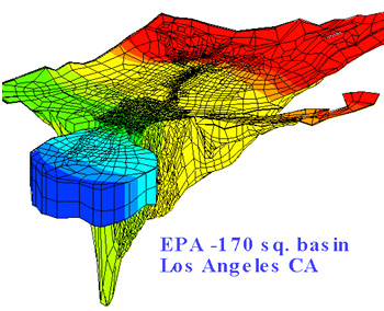 |
One of the largest contaminated groundwater basin evaluated under direct supervision of EPA
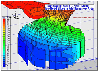
CFEST technologies provided efficient means for 3D representation of depth, external boundary, rivers, lakes, faults.
Interactively the grid is refined for each area of interest
CFEST 2D/3D displays provide detailed understanding of basin features and output
 |
Currently commonly used finite difference codes have several limitations for complex natural systems. |
|
|
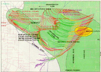
For accurate estimation of path lines, CFEST particle travel lines
are estimated using refined grid and time dependent head variations.
Color coded paths effectively display movement of particles
through geologic layers.
CFEST path lines assisted the EPA for ROD negotiations with the
responsible parties. |
 |
|
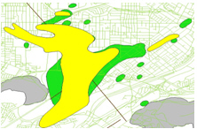
CFEST code efficiently models shallow and
deep plumes in the San Gabriel basin |
CFEST ISO_HEAD and ISO_CONC
slices provide detailed understanding contaminant variations in 3d. |
|
|
|
For your site, EWM team would like to set up systematic cost efficient state-of-the-art data management, modeling,
remediation, regulatory compliance, and other routine environmental/groundwater needs.
Back to Top |
|
|
|
| Copyright © 2024
by EWM Group. All Rights Reserved.
|
|