|
|
| |
Environmental Characterization, Data
Processing, RI/FS and Remediation
|
EPA remediation and long term monitoring guidance specially identify need and effective use of site specific details on following key fields.
- Geology
- Hydrogeology (types and number of aquifer systems, depth to groundwater, hydraulic pressure, flow direction, and velocities
- Types of soil (e.g. clayey soils allow less leaching than sandy soils)
- Amount of water percolation (which depends on rainfall, standing water on a site, and nature of soil)
- Background conditions and location of potential off-site pollution sources
- Horizontal and vertical distribution of chemical substances and by-products of decomposition
- Physical properties of chemical substances (e.g. density, viscosity, solubility)
- Potential for changes in chemical fate and transport throughout remediation process
- Size and static pressure of the contamination source (e.g. underground storage system
EWM has been developing and providing tangible support to U.S. EPA, DOE, and DOD for several sites.
|
EWM Superfund site support to EPA included oversight reviews of documents provided by the site contractors. EWM provided EPA capabilities to upload electronic data of voluminous hard copy “box full of reports” and generated informative summary tables, graphical displays, and independent modeling of sites. Our rating by EPA and DOE managers
EWM 10 commandments (home page) are designed to efficiently address EPA 9 criteria for evaluating remedial alternatives to ensure that all important considerations are factored into remedy selection decisions |
Following is a brief discussion of EPA guideline and EWM unique capabilities for providing supportive services to our clients.
EPA Guideline “Evaluate available data and develop a well-defined conceptual site model (CSM) in the earliest stages of the baseline risk assessment. The CSM is a three- dimensional "picture" of site conditions that illustrates contaminant sources, release mechanisms, exposure pathways, migration routes, and potential human and ecological receptors.
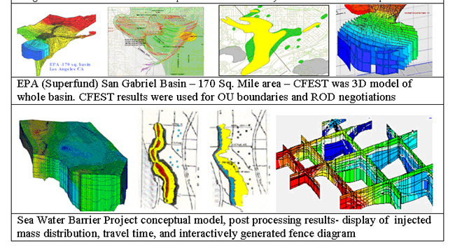
EWM uses its GoodRep (site data repository), SHOWME (automated multimedia data visualization), CFEST (Coupled Fluid, Energy, and Solute Transport 3D finite element code) for development of credible SCM.
 |
Why environmental projects need EWM technologies?
“Real World” groundwater basins are large. Geologic layering and surface water bodies have highly irregular shapes and sizes. Most of the site contractors do not develop a well defined conceptual site model (CSM) prior to developing monitoring plan and data processing. EWM provides easy means to develop, view, and modify CSM. EWM 3D finite element models are designed to change local scale grid on fly.
EWM efforts are designed to setup systematic site databases, data visualizations, and SCM for detailed assessment of contaminant sources, release mechanisms, exposure pathways, migration routes, and potential human and ecological receptors. |
EPA guidelines: The CSM documents current and potential future site conditions has to be supported by maps, cross sections, and site diagrams that illustrate what is known about human and environmental exposure through contaminant release and migration to potential receptors. The CSM should be modified as additional information becomes available. (RI/FS Guidance; DQO Guidance; Soil Screening Guidance; and RAGS I Part A)”
Back to Top |
In contrast to common practice of maintenance and submission of voluminous tabular data, EWM procedures provide easy means to upload wide types of electronic data and provide “real time” summary tables, concise informative displays, cross-sections and slices, which assist in appropriate implementation of project and making informed decisions at every stage of the project
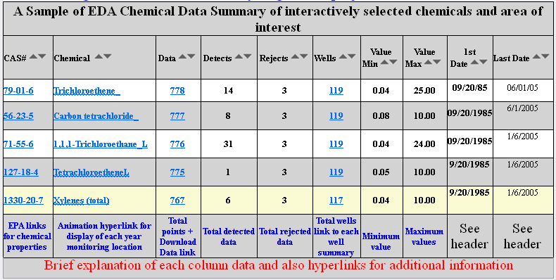
EWM tools automatically generate several thousands of informative displays over night to provide latest data status in “ready to use” formats. EWM displays include location map, regulatory compliance, monitoring station details, and geology.
Back to Top
|
|
EPA guidance
Exposure Pathways: Evaluate all relevant exposure pathways related to the site (e.g., direct ingestion, inhalation), for both current and reasonably anticipated future land uses as well as current and potential future ground-water and surface water uses. (Land Use Directive; RAGS I Part A; and Soil Screening Level Guidance)
Data Needs: Collect sufficient contaminant concentration data from each relevant medium to adequately characterize the nature and extent of contamination and to develop sound estimates of risk associated with each exposure pathway. (DQO Guidance |
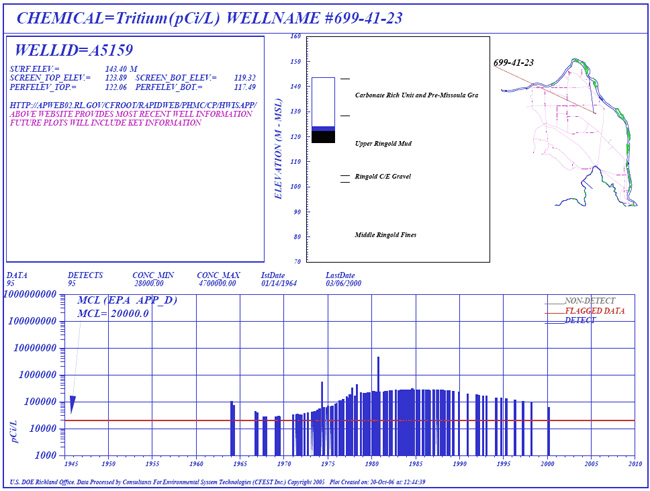
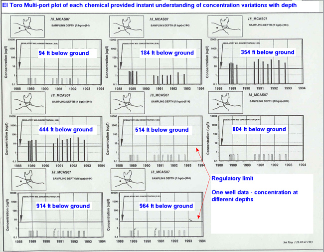
Multi-port sampling provides historical variations of concentration with depth. EWM SHOWME displays provide efficient means to evaluate multi-port information . These types of evaluations are needed at site characterization stage, remediation planning, remediation evaluations, and post remediations |
|
EWM state-of-the-art technologies assists in:
- Site-Specific Risk Calculation;
- Uncertainty or variability and their influence on the risk estimates;
- Probabilistic methods for evaluating uncertainty;
- Interfaces for exposed Populations;
- Ecological Risk Assessment; Basis for Action;
- Preliminary Remediation Goals for Carcinogens:
- Preliminary Remediation Goals for Non-Carcinogens; Chemical-Specific ARARs;
- Background Concentrations;
- Selecting Remedial Action, and developing A "phased approach" for site investigation and risk based cleanup within available budget.
Back to Top |
| |
|
|